Cooper Mountain Community Plan OOH 3 Logo
  • Welcome to the Cooper Mountain Community Plan Online Open House #3!

    The Cooper Mountain area includes over 1,200 acres along Beaverton’s southwestern city limits. In this online open house, we are asking for your input on different ways the City of Beaverton could create new, welcoming neighborhoods on Cooper Mountain. The open house will be open for comments through April 4. It should take you about 20 minutes to complete. After April 4th, the open house will be available to view, but will no longer accept feedback. 
  • Open House Stations

    There are a series of stations where you can learn about the alternatives and provide input. Go directly to a station using the buttons above or click "Next" to move through the stations in order.

    On the last page of the open house, you can leave your contact information to be entered into a raffle to receive one of several gift cards to a local Beaverton restaurant!

    Mobile device users: You may need to rotate your device to view some content on this site.

    Visualice este contenido en español

  • Illustration of a community landscape

  • Background

    The Cooper Mountain Community Plan will establish a long-term vision for the area’s growth and development to support welcoming, walkable neighborhoods that honor the unique landscape. Cooper Mountain is expected to provide at least 3,760 new homes, including a mix of housing types. This online open house is an opportunity to share your ideas and opinions on the three plan alternatives that show different ways we could create new Cooper Mountain neighborhoods.
  •  

    What we've heard so far

    During previous engagement efforts, stakeholders and community members shared what’s most important to them and what concerns they have for the area. Priorities and concerns include:

    • Preserving natural resources and wildlife habitat.
    • Creating a walkable community.
    • Providing easy access to nearby shops, parks, and other destinations.
    • Providing housing options for a variety income levels, including affordable housing.
    • Addressing concerns and/or hesitancy about changes to the Cooper Mountain area and future development.
  •  

    Map of Project Area

    Map of Project Area (Click to enlarge)

  • The plan alternatives described in this open house reflect input we’ve received from stakeholders and community members over the last two years. Now we're asking for your input to help us identify the best ideas in these alternatives.

    Learn more about the project by reviewing the following documents:

    • To review the plan alternatives, please see the Alternatives Evaluation Report.
    • To review public engagement summaries, please visit the Public Engagement tab of the Cooper Mountain project website.
    • For a summary of existing conditions, please see the Existing Conditions Snapshot.
    • For a summary of plan opportunities, please see the Opportunities Snapshot.

    Making Equitable Places

    The Community Plan is being developed using a racial equity approach to prioritize work that increases access and opportunities for historically underrepresented communities, including people of color, immigrants, and refugees. Many of the options discussed in the plan alternatives have equity implications. These include:

    • The amount, types, and costs of new housing.
    • Access to parks, nature, views, shops, and public facilities.
    • Transportation options that are designed to meet the needs of people walking, biking, taking transit, or people using mobility devices.
    • Opportunities for local entrepreneurship.

    Please consider the implications of the various options on historically underrepresented communities as you view the different alternatives included in this online open house.

    Project goals

    The Council-supported project goals include:

    1. Create equitable outcomes for residents, including historically under served and underrepresented communities.
    2. Provide new housing in a variety of housing types and for all income levels.
    3. Preserve, incorporate, connect, and enhance natural resources.
    4. Improve community resilience to climate change and natural hazards.
    5. Provide public facilities and infrastructure needed for safe, healthy communities.
    6. Provide safe, convenient access to important destinations while supporting transportation options, including walking and biking.
    7. Provide opportunities for viable commercial uses, including places to work and places to buy goods and services.
    8. Identify feasible, responsible funding strategies to turn the vision into a reality.

    Please consider these goals as you visit each open house station.

    Please share your thoughts on the draft alternatives by clicking the buttons above or clicking "Next."

  • Plan Alternatives

    The three alternatives show different ways we could use land, set up roads and trails, approach natural resource areas, and other ways we can plan for future growth on Cooper Mountain.
  • diagram showing how a preferred alternative will be created out of the three alternatives

  • Community feedback will be used to identify the best ideas within the alternatives to produce a “Preferred Alternative.” It will likely be a mixture of the alternatives and include new ideas identified through this process. 

  • Let's look at the alternatives.

  • Alternative A


    • 3,760 homes
    • Least variety in housing types
    • One commercial area
    • Moderate natural resource protection (creeks and trees)
    • Most new collector roads (2-3 lanes)
    • 17.5 acres of new neighborhood parks
  • Map of Alternative A

    (Click to enlarge)

  • Alternative B


    • 5,000 homes
    • Most variety in housing types
    • Two commercial areas, some opportunity for small-scale businesses
    • High natural resource protection
    • Several new collector roads, no road crossing of Summer Creek
    • 27.5 acres of new neighborhood parks
  • Map diagram of Alternative B

    (Click to enlarge)

  • Alternative C


    • 6,000 homes
    • Greatest variety in housing types
    • Two commercial areas, more opportunity for small-scale businesses
    • Highest natural resource protection
    • Fewer new collector roads
    • 31.5 acres of new neighborhood parks, one new community park
  • Map diagram of Alternative C.

    (Click to enlarge)

  • All alternatives include:

    • Middle housing types.
    • Target for 10 percent of all homes to be affordable housing.
    • Planned Washington County road projects, such as realigning the curves at SW 175th Ave and Tile Flat/Grabhorn Road.
    • Key sewer, stormwater, trail, and nature connections between the Weir/175th area and the Tile Flat/Grabhorn area (known as the McKernan Creek Greenway).
    • A bike and pedestrian network.
    • New trail connections to Cooper Mountain Nature Park.
    • A green network of wetlands, creeks and forested areas that provide wildlife habitat – about 500 acres.
  • images of different types of middle housing

    Different types of middle housing. (Click to enlarge)

  • Places to Live

    Beaverton wants to provide a range of housing choices that meet the needs of existing and future Cooper Mountain residents.
  • Number of homes and housing mix

    The three alternatives provide different options for the total number of housing units and variety of housing types. The city needs to plan for at least 3,760 new homes in Cooper Mountain.

    Alternative A Alternative B Alternative C
    Alternative A provides 3,760 homes. About two-thirds of this housing is assumed to be single-detached units. Alternative B provides 5,000 homes, with a greater proportion of attached and middle housing units.

    Alternative C provides 6,000 homes, with an emphasis on multifamily housing and middle/attached units.

    Chart of housing variety in each alternative


    Alternative A provides the least variety and affordable choices, while Alternative C provides the most variety and affordable choices. Alternative B is in-between.

    Smaller or attached units tend to be lower in cost than single-detached homes. However, a newly built home usually is more expensive than a similar older home.

    Learn more about these housing choices and the implications for the plan.

    Please note that all questions have been disabled and are in read-only mode.

  •  
  • 0/100
  • Arranging Housing in Neighborhoods

    The options below provide choices about how different housing types might be arranged in neighborhoods.

  • Option A

    Different housing types are built on separate blocks or in separate subdivisions.

    Diagram of different housing types built on separate blocks or in separate subdivisions.

    (Click to enlarge)

  • Option B

    Different housing types are built on the same block or in the same subdivision.

    Diagram of different housing types built on the same block or in the same subdivision.

    (Click to enlarge)

  • 0/100
  • Multifamily Housing

    There are different ways we could distribute multifamily housing in neighborhoods, which are often placed near public transit routes, parks, and shopping centers. Multifamily areas are shown in orange on the maps below. Parks are shown in green, while commercial areas are shown in red and purple.

    Alternative A Alternative B Alternative C
    Map diagram of Alternative A Map diagram of Alternative B Map diagram of Alternative C

    (Click to enlarge)

     
  •  
  • Places to Work and Shop

    The city would like to create a plan for commercial areas in Cooper Mountain where local shops and services can go. Commercial areas could also serve as community gathering places.
  • A market study found that a small commercial area could work in Cooper Mountain. The alternatives provide options for the size, number, and location of future commercial areas. Some alternatives also allow for small businesses within neighborhoods that people could easily walk, bike, or take public transit to.

    The size of commercial areas described in the alternatives include:

  • Larger commercial area

    (Alternative C)

    A large commercial center with an “anchor” store such as a grocery or pharmacy. These centers are usually 10 acres or more in size. The market study said a commercial development of this size was less likely to be successful because the future demand from people living nearby and driving by might not be high enough to support it.

    diagram of large commercial area

    images of large commercial areas

  • Smaller commercial area

    (Alternatives A, B, C)

    A smaller, neighborhood commercial center does not have an anchor store, but does have small shops and services (such as restaurants, coffee shops, salons, and doctor’s offices). These centers are usually about 5 acres or less. The market study found that a commercial development of this size was more likely to be successful because the future demand would likely support it.

    diagram of smaller commercial area

    examples of smaller commercial areas

  • Small-scale businesses within neighborhoods

    Alternatives B and C would allow small neighborhood-based businesses in residential areas. The idea is to provide small-scale services, support local small businesses and entrepreneurship, and reduce reliance on cars. The images below show examples of what this could look like.

    aerial small neighborhood-based businesses in residential area


    The three alternatives arrange commercial options in different ways described below (click each photo to enlarge):

    Alternative A Alternative B Alternative C
    Map diagram of Alternative A Map diagram of Alternative B Map diagram of Alternative C
        (Click to enlarge.)
    • One commerial center at SW 175th Ave/Weir
    • Best market feasibility
    • Two commercial centers: SW 175th Ave/Weir and Cooper Lowlands (interior)
    • Some small-scale businesses
    • Two commercial centers: larger at SW 175th Ave/Weir, Tile Flat
    • Most opportunity for small-scale businesses
  • Learn more about these commercial choices and the implications for the plan.

    Please note that all questions have been disabled and are in read-only mode.

  •  
  • 0/100
  • Places to Play

    Cooper Mountain will have many places to play: neighborhood parks, a potential new Community Park, plazas, and trailhead parks. These parks and open spaces will be connected to each other by trails and paths throughout the community.
  • All three alternatives include parks for each neighborhood in Cooper Mountain. The amount of total neighborhood park acreage increases from Alternative A to B to C because the number of households increases in each alternative. The neighborhood parks are intended to be part of a larger park system described below.

    Neighborhood Parks

    Some neighborhood parks might be located at the “edge” of neighborhoods next to natural areas and trails. Others might be within neighborhoods, surrounded by homes and neighborhood activity. Cooper Mountain has the potential for parks to be placed in different places, depending on the neighborhood.

  • Integration within neighborhood, next to regional trail

    diagram showing parks integrated within a neighborhood, next to regional trail
    (Click to enlarge.)

  • Central to neighborhood

    diagram showing a park situated centrally in a neighborhood(Click to enlarge.)

    1. Park is located along a natural area with comfortable walkways to access regional trail. 
    2. Homes face edges of the park as well as public streets.
    1. Various types of homes face the park from across neighborhood streets with convenient and safe crosswalks. 
    2. Park is located centrally to a neighborhood within walking distance from many homes. 
    3. Pedestrian pathways connect toward other areas.
  • Community Park

    Alternative C includes a new Community Park, which would be larger than the neighborhood parks and serve the entire community. At 10+ acres, it could include sports fields, sport courts, picnicking areas, and similar facilities for larger groups and community events. The image below is an example of a Community Park.

    Tualatin Hills Park & Recreation District (THPRD) has identified a need for a larger Community Park serving the Cooper Mountain community, so it could be implemented with any of the alternatives.

  • diagram of a community park

    (Click to enlarge.)

    1. Pedestrian walkways connect to surrounding neighborhood.
    2. Parking areas designed to prioritize pedestrians and park activity.
    3. Athletic fields located on existing flat areas.
    4. Small commercial area nearby provides supporting services.
    5. Park located close to major roads to allow greater community access.
  • Alternative A Alternative B Alternative C
    map of alternative A map of alternative B map of alternative C

    (Click to enlarge)

    Please note that all questions have been disabled and are in read-only mode.

  • 0/100
  • Learn more about these park choices and the implications for the plan.

  • Connecting People and Places

    Roads, trails and multi-use paths, and public transit will be tailored to Cooper Mountain’s hilly setting and provide safe, convenient options for people walking, biking, driving, taking transit, or using wheelchairs or other mobility aids.
  • Bicycle paths, pedestrian paths, and trails

    The plan is to create a complete transportation system that includes:

    • Bicycle paths, pedestrian paths, and trails.
    • Connected streets.
    • A community that is “transit-ready.”

    The maps below show three alternatives for the bicycle, pedestrian and trail network. Each alternative has a combination of “on-street” facilities (sidewalks, multi-use paths, and/or bicycle lanes), off-street paths (where needed) and off-street trails.

    Alternative A Alternative B Alternative C
    Map of Alternative A Map of Alternative B Map of Alternative C
        (Click to enlarge.)
    Collector roads and local streets provide connections in Alternative A. Alternative B uses some “off-street” connections and creek crossings between neighborhoods. Alternative C relies heavily on “off-street” connections and bridges for people walking, biking, or using mobility devices.
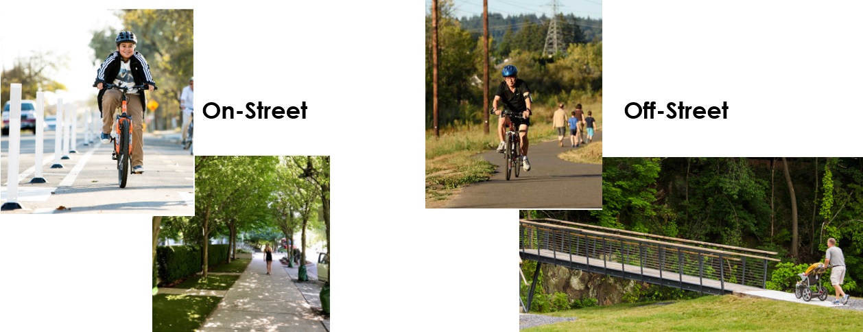
  • The images below are examples of on-street and off-street bicycle and pedestrian paths.

    images of examples of on-street and off-street bicycle and pedestrian paths.

    Making Cooper Mountain "Transit Ready"

    The Cooper Mountain Community Plan is an opportunity to plan land uses, community destinations, streets, and paths so that transit service can best serve the area for years to come. Beaverton supports this goal because it provides additional travel options, supports greenhouse gas reduction, and helps create an inclusive and welcoming community.

    Tri-Met already has plans to eventually extend Line 56 to Mountainside High School. To make the remainder of the area ready for transit, the alternatives:

    • Focus housing density, shops, and services in specific areas to create transit destinations.
    • Connect streets to support bus routing.
    • Strive to provide safe and comfortable routes and bus stops for pedestrians.

    We’re also planning to create “mobility hubs” – places where people can easily access bike/scooter rental and ride share pick-up near bus stops.

    Collector Routes

    The larger streets in the study area are known as arterial streets – this includes SW 175th Ave, SW Tile Flat Road and SW Grabhorn Road. They carry primarily “pass-through” traffic. In all alternatives, they will have 3 or more lanes, sidewalks and/or multi-use paths, and bike lanes.

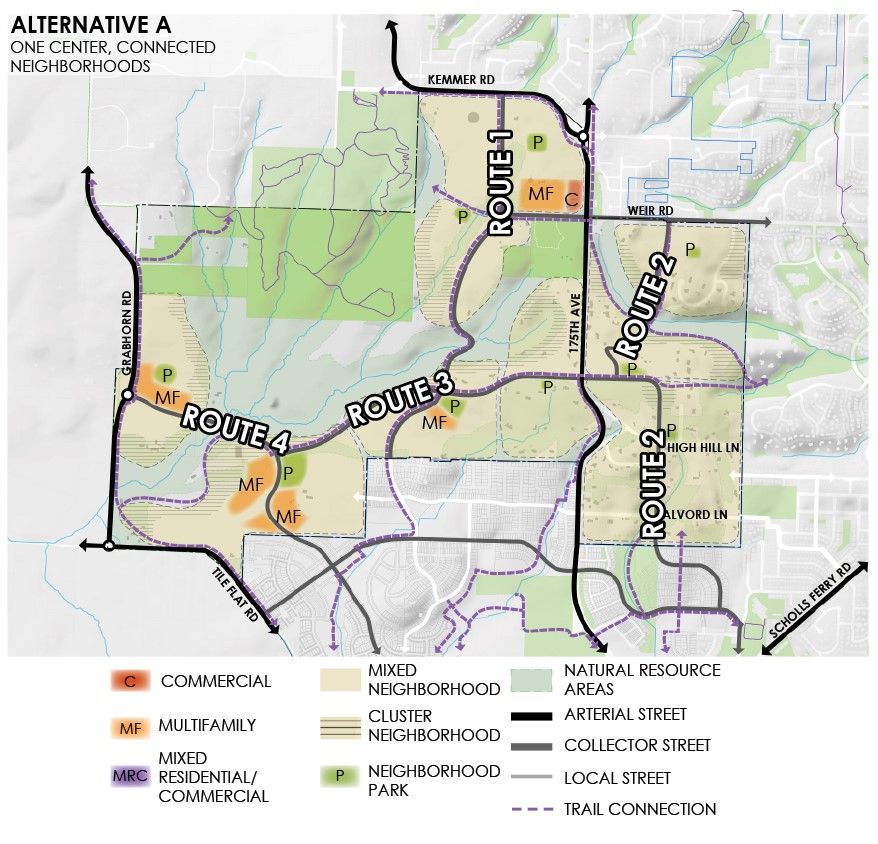
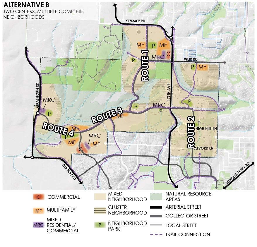
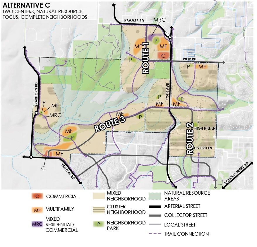
    The alternatives include options for collector roads – shown below as Routes 1, 2, 3, and 4. These future collectors are intended to carry primarily local traffic and would be 2 or 3 lanes and have sidewalks and/or multi-use paths and bike lanes. The potential collector routes shown below are an initial framework for the purposes of evaluating the alternatives. Each neighborhood would also have 2-lane streets (known as neighborhood routes and local streets) that would help people get to their homes, local businesses, and other destinations.

    The alternatives vary in their level of connectivity, impact on the arterials, and impact on wetlands, creeks, and forested areas. Each alternative has trade-offs. For example, Alternative A reduces dependence on SW 175th Ave by providing parallel north-south collector roads. Alternative A also has a higher environmental impact due to the bridges needed to cross the creeks.

    Please note that where collector roads are not present, off-road pedestrian and bicycle connections (including bridges over the streams) would be built.

    Collector Roads

    Alternative A Alternative B Alternative C
    Map of Alternative A collector routes Map of Alternative B collector routes Map of Alternative C collector routes
        (Click to enlarge.)
    • Least traffic on SW 175th Ave.
    • All neighborhoods connected by collector roads.
    • Highest environmental impact - 3 roads cross creeks.
    • Moderate traffic on SW 175th Ave.
    • Most neighborhoods connected by collector roads.
    • Moderate environmental impact - 2 roads cross creeks.
    • Most traffic on SW 175th Ave.
    • Fewest neighborhoods connected by collector roads.
    • Lowest environmental impact - no new stream crossings.


    Please note that all questions have been disabled and are in read-only mode.

  • 0/100
  • Learn more about these transportation choices and the implications for the plan.

  • Places for Nature and People

    Protecting and enhancing the unique natural environment of Cooper Mountain is a key element of the Community Plan.
  • Natural Resource Protection

    Cooper Mountain is home to many important natural resources, including sensitive riparian and upland habitat areas, wetlands, mature trees, McKernan Creek and its tributaries, the headwaters of Summer Creek, a network of wildlife corridors, and Cooper Mountain Nature Park.

    Riparian and upland habitats (shown here) are protected in all three alternatives.

    Additionally, the three alternatives include important wildlife corridors, the McKernan Creek Greenway, road crossings that accommodate wildlife passage, and access to nature for people throughout the Cooper Mountain community.

  • Map of Riparian and Upland Habitats

    Riparian and Upland Habitats (Click to enlarge)

  • Cluster Neighborhood Concept

    The following graphic illustrates the principles of “clustering” housing in new neighborhoods so that development preserves existing mature trees or other important natural features. The plan could provide more flexible development rules to encourage protection of existing trees during development. This could result in new homes (attached or detached) being closer to the street, closer to the property line, or taller in height.

  • Diagram of cluster neighborhood concept

    (Click to enlarge.)

    1. Existing trees preserved in side and front yards.
    2. Existing trees preserved in backyards, trail corridor, and creek buffer.
    3. Stormwater planters in streetscape.
    4. Existing stands of trees preserved in pocket park.
    5. Preserved trees in public connections to trails between homes.
    6. Careful siting of attached and small-lot homes creates open spaces that preserve existing trees.
  • The maps below show where “cluster neighborhoods” would go in each alternative.

    Alternative A Alternative B Alternative C
    Map of Alternative A Map of Alternative B Map of Alternative C
        (Click to enlarge.)
    • Edge of protected natural areas.
    • Similar to Alternative A, at edge of protected areas.
    • Expands cluster neighborhoods, particularly east of SW 175th Ave.


    Please note that all questions have been disabled and are in read-only mode.

  • 0/100
  • Learn more about these natural resource choices and the implications for the plan.

  • Next Steps

    Thank you for taking time to participate in this open house! Your input will help the city create the preferred alternative for Cooper Mountain. If you would like to be entered into our raffle to win a gift card to a Beaverton restaurant, please provide your contact information on this page.
  • Before you leave, remember to submit your comments at the bottom of this page.

  • Join us for a virtual event on March 31st!

    You’re invited to join use for a virtual meeting on March 31st from 6 – 7:30 pm. This is an opportunity to learn about the project, discuss the plan alternatives, and ask questions to the project team. Register here for the meeting.

    Schedule

    The city is committed to engaging the community throughout the planning process. Public engagement activities will be accessible to a broad audience to ensure the plan incorporates a variety of ideas and feedback.

    The community plan is expected to be complete by 2023. Annexation and development will not occur until after the planning process is complete.

  • Final Questions

    Please note that all questions have been disabled and are in read-only mode.


  • 0/200
  • 0/200
  • Sign up for Project Updates!

    Provide the following optional contact information if you would like to be added to the project mailing list or have a member of the team contact you to discuss the project.

    If you would like to be entered into our raffle to win a gift card to a Beaverton restaurant, please provide your contact information here.

  • Contact Information

    Please contact Cassera Phipps with questions, comments, or concerns.

    Cassera Phipps
    Senior Planner, Community Development
    503-319-9414; cphipps@beavertonoregon.gov

  • Tell Us About Yourself

  • Map of project area and areas outside of the project

    (Click to enlarge)

  • Demographic Information (Optional)

    The following questions are optional and will help us understand who we are hearing from and whether we are reaching a wide range of people in the community. The identity of individuals is kept confidential. The results are reported as totals only and will be used solely to help improve future community engagement.

  • How many people, including yourself, live in your home?
    Adults:    
    Children:    

  • Should be Empty: