• HAWTHORNE Connections study

    HAWTHORNE Connections study

  • Ver este contenido en español open in new tab icon

  • Welcome to the Hawthorne Connections Study open house!

  • In this virtual open house you can:

    • Learn about the study and why it is needed.
    • Explore potential biking and pedestrian improvements for Hawthorne Avenue and Harriman Street.
    • Share your priorities for these future improvements.

    Aerial view of Hawthorne Avenue showing a wide commercial street with large parking areas, scattered buildings, and limited pedestrian or cycling infrastructure.
    Aerial view of Hawthorne Avenue.

    Aerial view of Harriman Street showing a neighborhood street lined with trees and low-rise buildings.
    Aerial view of Harriman Street.

  • To record your responses, be sure to click or tap the “Submit” button at the end.

    • Read More: Transportation Talk 
    • Transportation Talk

      Engineers and planners use lots of technical language to define transportation concepts. Here is a decoder for the rest of us!

      • Key Routes: Main routes in the City designed to be less stressful for people walking and bicycling that help people get across town safely and get to key destinations like schools and parks. Examples include off street multi-use paths, buffered, separated, raised and/or painted bike lanes, and widened sidewalks. Think of these as "highways" for biking and walking. (This is a term from the Bend Transportation System Plan.)
      • Low stress network: A network of streets and crossings (including the Key Routes) designed to allow everyone to travel safely and comfortably when biking, walking or driving. Think of these as “local roads” for biking and walking.
      • Protected bike facility: A facility for bikes that has a physical, stationary or vertical separation between cars and bikes - like a curb or plastic pole.
      • Shared-use path: A wide path for people walking, biking, or rolling that's separate from vehicles. Shared-use paths can provide a less stressful experience for transportation or recreation uses. A shared-use path can be part of a key route.
      • Sharrows: Lane markings that indicate bikes may be riding in the street and drivers should use extra caution.
      A protected bike lane separated from traffic by a curb and plastic posts.

      Protected bike facility

      Pedestrians walking on a wide paved path separated from the roadway.

      Shared-use path

      A cyclist riding in a street lane marked with a sharrow symbol.

      Sharrows

    •  
  • Project Overview

  • This study is evaluating gaps in the City’s Key Bicycling and Walking Routes surrounding the Hawthorne Crossing, a planned pedestrian and bicycle bridge over the Parkway and railroad. The project will study how to make it easier and safer for people to travel around Bend and support future access to the bridge.

    There are two segments where there are gaps between planned or on-going projects:

  • NE Hawthorne Avenue between NE Third Street and NE Fifth Street

    Goal: To provide a safer, more comfortable route across Third Street to popular east‑side destinations like Juniper Swim & Fitness Center, and provide access to Hawthorne Crossing from the east.

    NW Harriman Street between NW Greenwood Avenue and NW Franklin Avenue

    Goal: To create a safer, better connection between Greenwood Avenue and Franklin Avenue, and provide access to Hawthorne Crossing from the west.

    Project area map showing the two study segments and their relationship to Hawthorne Crossing and surrounding key walking and biking routes in Bend. Project area map showing Harriman St between Greenwood Ave and Franklin Ave and Hawthorne Ave between Third St and Fifth St.

    🔍 View larger ↗

  • The following pages present options for improving these two segments. This project is not currently funded for design or construction, so a range of options that would require varying levels of investment and impact have been considered. 

  • Considerations

    The two segments in this study are classified as local streets, which are meant to provide access to individual properties and are typically lower-speed, lower-traffic routes. Some other things we needed to consider in creating options for the Hawthorne Avenue and Harriman Street connections include:

    • Lower traffic volumes on Hawthorne Avenue and Harriman Street: With the decision to fully close the on-ramp and off-ramp for US 97, traffic volumes are expected to drop. Modal filters at the Harriman Street/Greenwood Avenue and Harriman Street/Franklin Avenue intersections will also decrease vehicle volumes.
    • Fire access requirements: Emergency services require 20-foot-wide clear space between curbs (26 feet for buildings three stories or taller).
    • Phasing considerations: To balance near-term needs with funding constraints, all options studied may require a phased, short-term solution that maintains the existing street curbs, pavement and drainage, with more extensive options that can be phased in and funded later.
    • Intersection traffic control considerations: The concept options at the Harriman Street/Hawthorne Avenue, Harriman Street/Irving Avenue and Hawthorne Avenue/Third Street intersections will affect how comfortable people feel walking and biking in the study area.
  • Timeline

    Use this open house to let us know your priorities as the project team considers future design features.

    Later in 2026, City Council will consider public input from this open house along with discussions on the benefits and costs associated with each of the options to determine next steps on these two segments.

  • Options for Harriman Street between Greenwood Avenue and Franklin Avenue

  • For the Harriman corridor, there are two options, with slightly different designs shown, north of Irving and south of Irving, due to different existing street widths.

    More detailed drawings for each option are linked at the bottom of the page.

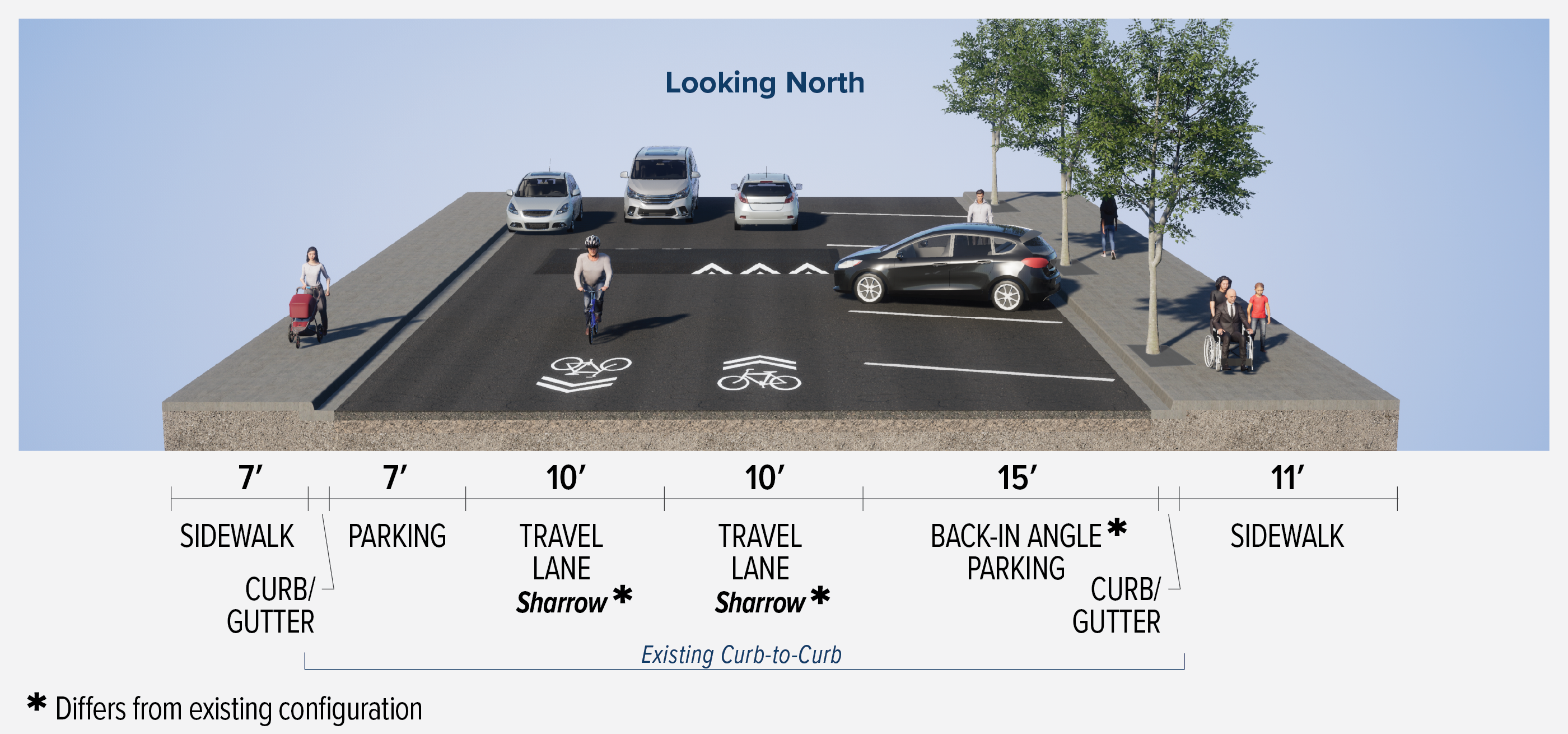
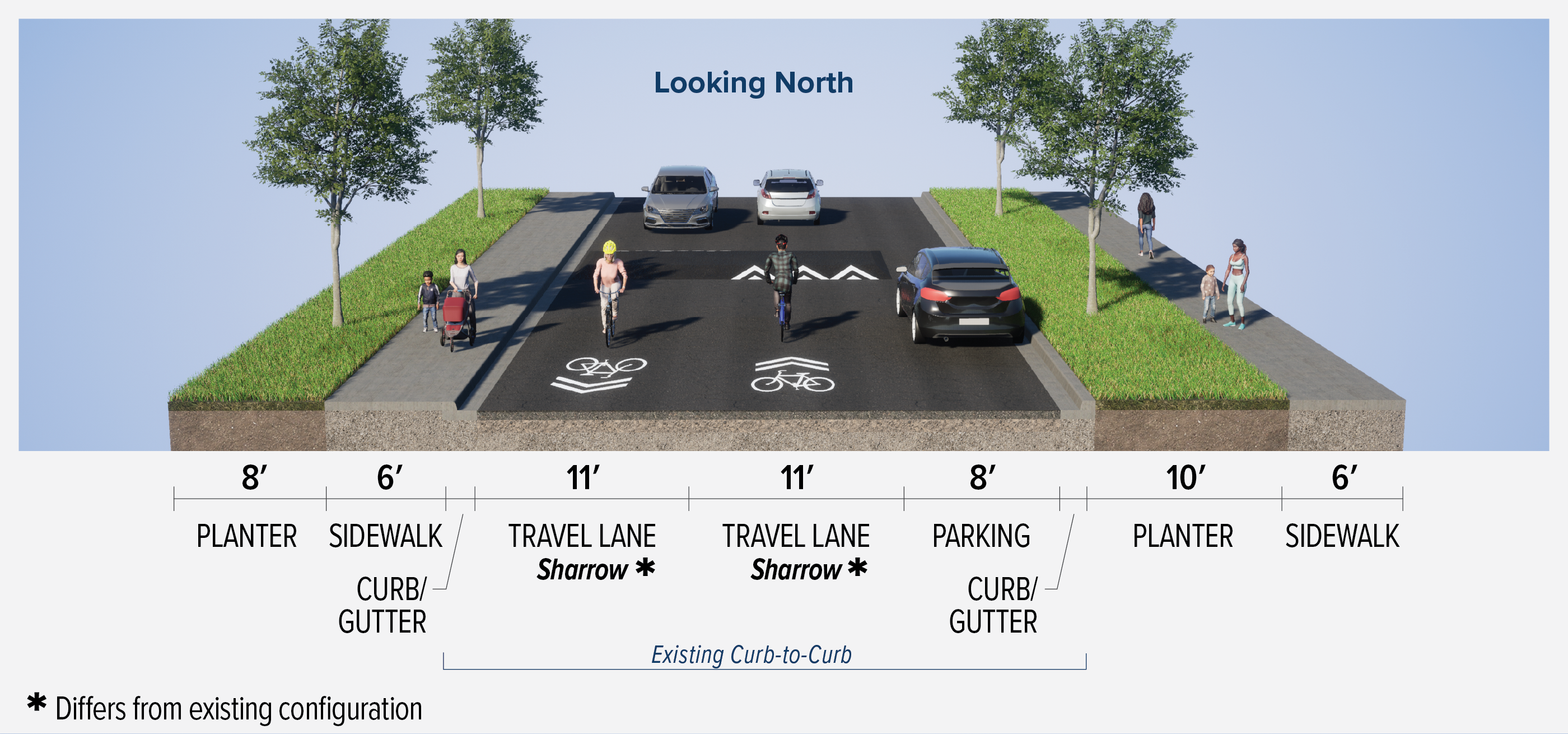
  • Option 1: Sharrows and Speed humps

    This option is lower-cost and lower-impact by keeping the existing curb lines on both sides of the road. The existing sidewalk and landscaping are also maintained.

    This option would introduce traffic calming measures like:

    • speed humps and curb extensions
    • pavement markings sharrows (bicycle markings in the lane for sharing space with vehicles)
    • parking on alternating sides of the street to create a slower, “slalom effect” driving path

    This option maintains parking spots while still reducing vehicle speeds.

    Back-in angle parking is shown as an option to provide better visibility of people biking in the street.

    Harriman Option 1 between Greenwood Avenue and Irving Avenue.

    Cross-section rendering of Harriman Option 1 between Greenwood and Irving Avenues, looking north.

    🔍 View larger ↗

    Harriman Option 1 between Irving Avenue and Franklin Avenue.

    Cross-section rendering of Harriman Option 1 between Irving and Franklin Avenues, looking north.

    🔍 View larger ↗

  • Option 2: Shared-Use Path

    This option has people biking and walking on the same path with a promenade-style shared use-path on the west-side of Harriman Street between Greenwood and Franklin. It would create an extension of the promenade on Hawthorne Avenue planned between Hill and Harriman streets, as part of the Hawthorne Crossing project.

    This option maintains the existing sidewalk and landscaping on the east side of the road, with:

    • a wider shared-use path on the west side of Harriman Street
    • two-way vehicle travel lanes

    Harriman Street Option 2 between Greenwood Avenue and Irving Avenue

    Cross-section rendering of Harriman Street Option 2 between Greenwood and Irving Avenues, looking north.

    🔍 View larger ↗

    Harriman Street Option 2 between Irving Avenue and Franklin Avenue

    Cross-section rendering of Harriman Street Option 2 between Irving and Franklin Avenues, looking north.

    🔍 View larger ↗

  • Quick Comparison:
    Harriman Street Options Between Greenwood Avenue and Franklin Avenue

    ★ Advantage
    ● Neutral
    ■ Disadvantage

    Option 1: Sharrows and Speed Humps

    ★ Cost Range

    ~$200,000

    ● Walking and Biking Separation

    Same separation as today

    ★ Vehicle Speeds

    Intersection elements and traffic calming elements in the shared street space reduce speeds

    ★ On-street Parking

    Parking count similar to today

    Option 2: Shared-Use Path

    ■ Cost Range

    ~$2,000,000

    ★ Walking and Biking Separation

    Separates people walking/biking from vehicles

    ★ Vehicle Speeds

    Intersection elements reduce speeds

    ■ On-street Parking

    Reduces parking by 50%

    ● Other

    Requires changing curb lines on the west side of the road.

  • View full PDF for option 1 open in new tab icon

    View full PDF for option 2 open in new tab icon

  • This project is not currently funded for design or construction, so we considered a range of options that would require varying levels of investment and impact. Later in 2026, City Council will consider public input from this open house along with discussions on the benefits and costs associated with each of the options to determine next steps on these two segments.

  • Question

  • To record your responses, be sure to click or tap the “Submit” button at the end.

  • Harriman Street Intersections

  • Intersections are places where people come into conflict with one another. They can create an additional barrier for people walking, biking or rolling. They can also be an opportunity to limit the number of cars entering a street and encourage drivers to reduce their speed, making it safer for everyone.

    Greenwood Avenue and Franklin Avenue

    These two intersections have recently been redesigned through the Midtown Crossings Project. They both currently, or will soon, include partial medians for safer crossing. Depending on which options are selected for the Harriman Street design, these intersections may stay the same or adjustments may be needed to maintain connectivity and safety.

  • A concrete median island at an intersection on a neighborhood street, narrowing the crossing distance for pedestrians.
    Example of a partial median to improve safety crossing.

    Map of the Harriman Street study area highlighting intersections with yellow dots. Along the Harriman Street segment, intersections are marked at Greenwood Avenue, Oregon Avenue, Irving Avenue, Franklin Avenue, and Hawthorne Avenue. Map showing the intersections included in the study.

    🔍 View larger ↗

  • Minor Intersections

    Below are several different options for intersection safety improvements that can be implemented at the less busy intersections.

    A stop sign with an 'All Way' plaque at a residential intersection.

    All-way Stop

    A street intersection with extended curbs that narrow the roadway at the crosswalk, reducing pedestrian crossing distance.

    Curb Extensions

    Source: James R. Barrera, FHWA Traffic Calming ePrimer

    A crosswalk elevated to sidewalk height across a street, with a pedestrian crossing sign visible.

    Raised Crosswalk

    Source: Scott Batson, FHWA Traffic Calming ePrimer

    An intersection where the entire roadway surface is raised to sidewalk level, with colored pavement marking the crossing area.

    Raised Intersection

    Source: City of Cambridge

  • To record your responses, be sure to click or tap the “Submit” button at the end.

  • Options for Hawthorne Avenue between Third Street and Fifth Street

  • For the Hawthorne corridor, there are three options, with slightly different designs shown west of Fourth Street and east of Fourth Street, due to different existing street widths.

    More detailed drawings for each option are linked at the bottom of the page.

  • Option 1: Sharrows and Speed Humps

    This option is lower-cost and lower-impact by keeping the existing curb lines on both sides of the road. The existing sidewalk and landscaping are maintained in this option. This option would include:

    • Two-way vehicle traffic
    • Speed humps and other traffic calming features

    Hawthorne Option 1 between Third Street and Fourth Street

    Cross-section rendering of Hawthorne Option 1 between Third and Fourth Streets, looking west.

    🔍 View larger ↗

    Hawthorne Option 1 between Fourth Street and Fifth Street

    Cross-section rendering of Hawthorne Option 1 between Fourth and Fifth Streets, looking west.

    🔍 View larger ↗

  • Option 2: Cycle Track

    This option adds more separation between people biking and vehicles. It offers a lower overall cost by maintaining both curb lines where they are today. The design would include:

    • 14-foot-wide two-way cycle track on south side of the street
    • 2-foot buffer between cycle track and vehicle lane
    • One-way westbound vehicle traffic

    Hawthorne Avenue Option 2 between Third Street and Fourth Street

    Cross-section rendering of Hawthorne Option 2 between Third and Fourth Streets, looking west. From left to right: 10-foot sidewalk (differs from existing), 14-foot cycle track with 2-foot buffer (both differ from existing), 10-foot one-way travel lane (differs from existing), 10-foot bus parking, 10-foot sidewalk with curb/gutter, and 4-foot planter.

    🔍 View larger ↗

    Hawthorne Option 2 between Fourth Street and Fifth Street

    Cross-section rendering of Hawthorne Option 2 between Fourth and Fifth Streets, looking west. From left to right: 12-foot planter, 15-foot cycle track with 3-foot buffer (both differ from existing), 12-foot one-way travel lane (differs from existing), 10-foot planter with curb/gutter, 6-foot sidewalk, and 2-foot planter.

    🔍 View larger ↗

  • Option 3: Shared-Use Path

    This option provides the most separation between people walking or biking and vehicle traffic. This design would be most consistent with the planned cross-section between Second and Third streets, as part of the Hawthorne Crossing project. Design features include:

    • Continuous south-side shared-use path (maintains the existing north curb line)
    • One-way westbound vehicle traffic

    Hawthorne Avenue Option 3 between Third Street and Fourth Street

    Cross-section rendering of Hawthorne Option 3 between Third and Fourth Streets, looking west. From left to right: 2-foot hardscape (differs from existing), 14-foot shared-use path (differs from existing), 8-foot planter with curb/gutter (differs from existing), 14-foot one-way travel lane (differs from existing), 8-foot bus parking, 10-foot sidewalk with curb/gutter, and 4-foot planter.

    🔍 View larger ↗

    Hawthorne Avenue Option 3 between Fourth Street and Fifth Street

    Cross-section rendering of Hawthorne Option 3 between Fourth and Fifth Streets, looking west. From left to right: 14-foot shared-use path (differs from existing), 6-foot planter with curb/gutter (differs from existing), 14-foot one-way travel lane (differs from existing), 8-foot parking with curb/gutter, 10-foot planter, 6-foot sidewalk, and 2-foot planter.

    🔍 View larger ↗

  • Quick Comparison:
    Hawthorne Avenue Options Between Third Street and Fifth Street

    ★ Advantage
    ● Neutral
    ■ Disadvantage

    Option 1: Sharrows and Speed Humps

    ★ Cost Range

    ~$650,000

    ● Walking and Biking Separation

    Same separation as today

    ★ Vehicle Volumes and Speeds

    Will reduce speed of vehicles to improve safety

    ● Traffic Pattern

    Two-way

    ★ On-street Parking

    Parking count similar to today

    Option 2: Cycle Track

    ★ Cost Range

    ~$850,000

    ★ Walking and Biking Separation

    Provides separation from vehicle traffic but driveways will limit the use of bollards or plastic poles

    ★ Vehicle Volumes and Speeds

    Will reduce speed and number of vehicles to improve safety

    ● Traffic Pattern

    One-way (westbound)

    ● On-street Parking

    Reduces parking by 25%

    Option 3: Shared-Use Path

    ■ Cost Range

    ~$2,000,000

    ★ Walking and Biking Separation

    Separates people walking/biking from vehicles

    ★ Vehicle Volumes and Speeds

    Will reduce speed and number of vehicles to improve safety

    ● Traffic Pattern

    One-way (westbound)

    ● On-street Parking

    Reduce to 25%

  • View full PDF for option 1 open in new tab icon

    View full PDF for option 2 open in new tab icon

    View full PDF for option 3 open in new tab icon

  • This project is not currently funded for design or construction, so we considered a range of options that would require varying levels of investment and impact. Later in 2026, City Council will consider public input from this open house along with discussions on the benefits and costs associated with each of the options to determine next steps on these two segments.

  • Questions

  • To record your responses, be sure to click or tap the “Submit” button at the end.

  • Hawthorne Avenue Intersections

    The way we design an intersection can help limit the number of conflicts between different travelers and reduce vehicle traffic on local neighborhood streets or streets with high numbers of people walking, biking, or rolling.

    Note: All Hawthorne intersection options assume the promenade treatment and westbound only traffic between Second and Third, consistent with the Hawthorne Crossing design.

  • Map showing intersections being considered along Hawthorne Avenue, with yellow dots marking intersections at Third Street, Fourth Street, and Fifth Street. The map also shows the Hawthorne Crossing, Harriman Street Connection, and Hawthorne Avenue Connection study segments, key walking and biking routes, and nearby landmarks including Marshall High School, Juniper Park, Juniper Swim & Fitness Center, and Bend Senior High School. Map showing locations of the intersections on Hawthorne Avenue being considered.

    🔍 View larger ↗

    A signalized intersection with green-painted bike lane markings, crosswalks, a traffic signal, and a median restricting left turns.
    Example of a potential design for Third Street / Hawthorne Avenue with a full signal and restricted left turns.

  • Hawthorne and Third Street intersection

    This intersection is a unique location because it is a Key Route crossing of a five-lane street, presenting a significant barrier to people walking or biking. Third Street will need additional features to create a safe and comfortable crossing. Third Street will, at a minimum, keep the flashing beacons as it has now, but could increase protections up to a full traffic signal with medians. Please note that adding a traffic signal to Third Street will require additional collaboration with the Oregon Department of Transportation (ODOT) and is anticipated to help keep traffic flowing through this section of Third Steet.

    Minor intersections (Fourth Street and Fifth Street)

    Similar options as noted for the Harriman Street minor intersections will be considered at Hawthorne Avenue minor intersections (e.g., all-way stop, curb extensions).

  • Priorities

  • Comments

  • Next Steps

    Thank you for participating in the Hawthorne Connections Study online open house.

    Your feedback will help us confirm that we are moving in the right direction for this work. 

    Sign up for project emails to stay in touch and learn more as we move forward.

  • Should be Empty: