• PCC Facilities Plan

    Online Open House 3

    Spring/Summer 2022
  • Draft Transportation System Plan Ready for Review

    The Cities of Manzanita, Nehalem, and Wheeler are finalizing the draft,joint Transportation System Plan and are seeking public review and feedback. Learn about the proposed projects and tell us what you think!
  • The interactive aspects of this online open house closed on July 5, 2022. If you have comments or questions, please reach out! You can leave a comment through the project website or contact James  Feldmann, ODOT Project Manager (James.FELDMANN@odot.oregon.gov).

  • Project area map.(Project Area - Click to enlarge)

    What is the TSP?

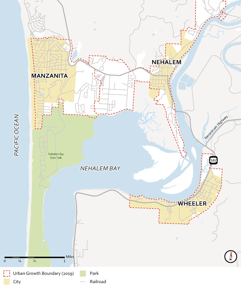
    The TSP will describe transportation goals, policies, project investments and strategies for the next 20 years. The final TSP will guide Manzanita, Nehalem and Wheeler in decisions about new transportation projects and programs, and will consider travel needs for people who walk, use cars, ride bicycles, move freight, or ride the bus.


    Stations

    On this open house site there are a series of "stations" where you can learn about the project and provide input. Go directly to a station using the buttons above, or click "Next" to move through the stations in order.

  • Goals and Objectives

    The proposed TSP projects have been evaluated and prioritized based on a set of Goals that were developed by the three cities. The Goals have provided the project team with direction throughout the project and will guide the three cities after plans are adopted.
  • Regional Goals

    1. Enhance quality of life. Create a transportation system that provides equitable multimodal access for underserved and vulnerable populations and balances the needs of local travelers and regional through-traffic.

    2. Create safe connections. Create safer connections between the Nehalem Bay communities for people walking, biking, or using other non-auto modes and identify strategies to reduce crashes for all users when traveling on US 101.

    3. Plan for the future. Collaborate with ODOT and Tillamook County to create a transportation system that is resilient to extreme weather events, able to safely accommodate evacuation and recovery efforts, and consistent with the goals and objectives of each City, Tillamook County, and the state.

    4. Support fiscal responsibility. Plan for a transportation system that is financially viable with consideration for life cycle costs by identifying new funding sources to make local dollars go farther.

  • Manzanita Goals

    Photo Laneda Avenue in Manzanita.

    1. Manage access from Highway 101 to Manzanita and the recreational opportunities in the area to minimize cut through traffic and seasonal congestion.

    2. Support economic vibrancy and reduce parking demand by providing walking, biking, and transit connections to the commercial core.

  • Nehalem Goals

    U.S. 101 in Nehalem.

    1. Manage access. Increase connectivity and fill infrastructure gaps for people walking and biking to access key destinations such as schools, restaurants, and the commercial core.

    2. Access to the natural environment. Increase access to recreational areas and water-based travel options while protecting the natural environment.

  • Wheeler Goals

    Photo U.S. 101 in Wheeler.

    1. Create more travel options. Improve walking and biking safety, connections, and wayfinding within Wheeler.

    2. Enhance economic vibrancy. Support economic vibrancy by creating connections to recreational opportunities and new forms of local tourism while protecting the natural beauty that draws visitors to Wheeler.

  • Click "Next" to learn about projects intended to address "Regional Goals".

  • What We've Learned

    During this process, we've heard about the unique transportation challenges for each city and the region as a whole.
  • Photo of a sign on U.S. 101.

    Regional Challenges

    U.S. 101 serves many roles in the Nehalem Bay Region. It is the only connection between the cities of Manzanita, Nehalem, and Wheeler for people walking, biking, and driving and serves as an important regional route for people and goods traveling through the region. In recent years, most crashes in the Nehalem Bay Region have occurred on 101, including one crash involving a bicyclist. The regional projects identified would address this challenge by:

    • Implementing safety measures such as advanced warning signs, rumble strips, and curve delineation, where appropriate to reduce the number of crashes on U.S. 101.
    • Creating new routes off U.S. 101 for people walking and biking.
    • Upgrading infrastructure to improve resiliency in the event of a natural disaster.
    • Creating more options for people to travel between the cities without driving, reducing congestion in the region.


  • Photo Laneda Avenue in Manzanita.

    Manzanita Challenges

    Unlike the other Nehalem Bay communities, Manzanita does not have U.S. 101 traffic through its downtown commercial core, local roads connect visitors and residents to key local destinations. These roads must meet the needs of a variety of users, serving as the primary connection between the downtown core and the beach for people driving, walking, and biking. While Laneda Avenue and Carmel Avenue provide connections for people walking and biking, there are a lack of connections for these users between the city limits and UGB area to the east, which encompasses many homes. The projects identified for Manzanita would address these challenges by:

    • Providing amenities such as bicycle parking and improved wayfinding to make it easier for people to walk and bike to the downtown core.
    • Enhance existing roadways to identify space for people walking and biking, creating a more connected network for these users.
    • Using traffic calming measures to improve safety for all users on Laneda Avenue.


  • Photo of U.S. 101 in downtown Nehalem.

    Nehalem Challenges

    U.S. 101 bisects Nehalem and serves as the City’s “main street”. Having a major highway serving as “main street” creates congestion at the U.S. 101 and 7th Street intersection and poses challenges for residents that would like to walk or bike across U.S. 101 to access local destinations, including the grade school and recreation district. The potential projects identified for Nehalem would address these issues by:

    • Using low-cost improvements like signage and striping to identify space for people walking and biking on local roads.
    • Enhancing U.S. 101 crossings to improve safety and comfort for people crossing.
    • Constructing sidewalks to create a safe connection for students walking to the grade school.
    • Improving the condition of local roads, specifically those used by residents when flooding closes U.S. 101.
    • Using traffic calming measures to lower vehicle speeds on U.S. 101 through Nehalem.


  • U.S. 101 in downtown Wheeler.

    Wheeler Challenges

    In Wheeler, U.S. 101 separates the bulk of the downtown core, located on the south side of U.S. 101, from recreational destinations like the boat launch, marina, and Waterfront Park. The local streets also lack dedicated bicycle and pedestrian facilities to connect residents and visitors to these recreational opportunities. The potential projects identified for Wheeler would address these challenges by:

    • Enhancing local streets to identify space for people biking and walking with low-cost improvements such as signing and striping.
    • Improving existing sidewalks and crosswalks to create safer and more comfortable connections to local destinations.
    • Create missing connections between local streets to create a more connected roadway network off U.S. 101.
    • Using traffic calming measures to lower vehicle speeds on U.S. 101 through Wheeler.
  • Proposed Regional Projects

  • Refer to the map and the list of projects below. You can search the interactive list by name or keyword. Click the table headers to sort by category or project name. Information about projects labeled with "M" (Manzanita), "N" (Nehalem) and "W" (Wheeler) is available on city project pages.

  • Map showing proposed regional projects
    Click to enlarge

  • For more details: Download Project List PDF (3.1 MB)

  • Questions


  • Proposed Manzanita Projects

  • Recommended Solutions

    Refer to the map and the list of projects below. You can search the interactive list by name or keyword. Click the table headers to sort by category or project name. Information about projects labeled with "R" and "U" is available on the "Regional Projects" page.

  • Map showing proposed projects in Manzanita
    Click to enlarge

  • For more details: Download Project List PDF (3.1 MB)

  • Questions


  • Proposed Nehalem Projects

  • Recommended Solutions

    Refer to the map and the list of projects below. You can search the interactive list by name or keyword. Click the table headers to sort by category or project name. Information about projects labeled with "R" and "U" is available on the "Regional Projects" page.

  • Map showing proposed projects in Nehalem
    Click to enlarge

  • For more details: Download Project List PDF (3.1 MB)

  • Questions


  • Proposed Wheeler Projects

  • Recommended Solutions

    Refer to the map and the list of projects below. You can search the interactive list by name or keyword. Click the table headers to sort by category or project name. Information about projects labeled with "R" and "U" is available on the "Regional Projects" page.

  • Map showing proposed projects in Wheeler
    Click to enlarge

  • For more details: Download Project List PDF (3.1 MB)

  • Questions


  • Next Steps

    Thank you for participating! We will make additional refinements to the project list based on your feedback and present the final, proposed TSP to each city council this summer.
  • So ... When will projects be built?

    The timing for design and construction of individual projects will vary based on available funding. Once adopted, the TSP will serve as a starting point for securing funding for the projects that have been identified for each City and the region. Primary funding sources will likely include grants that are available to cities through State and Federal programs. These grants often provide funding for projects that improve safety, increase resiliency of the transportation network during natural disasters, and create or enhance facilities for people walking and biking.

    Having a TSP that has been vetted by the community and adopted by elected officials will help prepare the Nehalem Bay Region to apply for funding as it becomes available in the future.

  • Schedule

    • Background Plans and Policy Review (Winter-Summer 2021)
    • Understanding Existing Conditions (Summer 2021)
    • Develop and Evaluate Solutions (Summer-Fall 2021)
    • Draft TSP Update (Winter 2021- Spring/Summer 2022) - WE ARE HERE
    • Adopt TSP (Summer/Fall 2022)

    Stay Involved

    • Watch for information about upcoming City Council hearings and submit comments at NehalembayTSP.org.

    • Contact James Feldmann
      ODOT, Region 2 Planning
      541-257-7669 - james.feldmann@odot.oregon.gov
  • Before you leave, remember to submit your comments at the bottom of this page.

  • Final Questions


  • Mailing List

    Provide your contact information if you would like to be added to the project email list. (Optional.)

  • Demographic Questions

    We are requesting the following demographic information to help evaluate the effectiveness of our public outreach activities. Providing this information is voluntary.

  • Should be Empty: